| 35:10 - 35:50 | Nablus: Nablus is the major Palestinian city in the northern hill country. Its name comes from the Roman Neapolis - Arabic lacks a "p" sound. It sits where the Wadi Zeimar cuts between two mountains, Mt. Ebal to the north and Mt. Gerizim to the south. | ||||
| 35:50 - 36:00 | Shechem; Long before the Romans built Neapolis, there was Shechem. It is the first place located in the land mentioned in the Bible. Here is where Abraham first came. Jacob settled here for a period and bought land. Joseph's bones were brought here from Egypt. It was to Shechem the Israelites returned, under Joshua, to renew their covenant with God. Here, the northern tribes rejected Solomon's son, Rehoboam, as their king. And at nearby Sychar, Jesus shared water from Jacob's well with a Samaritan woman. The Shechem area, sitting here at the pass between Gerizim and Ebal, where the hill country's major highway intersected a major road linking the coastal plain and Transjordan, certainly deserved the name, "center of the land." | ||||
| 36:15 - 37:40 | Mt. Gerizim and Mt. Ebal: Before the Israelites entered the Promised Land, Moses told them to go to these two mountains standing over Shechem to renew their covenant. The tribes were divided between the two mountains and the covenant's blessings were recited from Gerizim and its curses from Ebal. Interestingly, the facing slopes between the two mountains form two natural ampitheaters that may be where the tribes stood to take advantage of the acoustics. You can see the deep semi-circular recesses as we loop back over Gerizim, Nablus and Ebal. Atop Gerizim is the home of the Samaritan community. The archaeological remains of their ancient temple -- noted in the story of Jesus and the woman at the well - are there as well as the site where the Samaritans still celebrate the Passover in a manner quite similar to that described in the Book of Exodus. | ||||
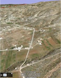
| 37:40 - 39:25 | El Mukhna: As we sweep back
over Shechem, we head south along a broad plain, called El Mukhna (if we had gone north,
we would have soon reached the Wadi Farah which leads down to the Jordan Valley and one of
the main fords across the river to reach Transjordan). Here we are, essentially at the top
of the hill country of Samaria and we're on a plain hemmed in by hills and mountains on
both sides. It will not be this way when we get to hills of Judah. Here, in Samaria, the
geologic structure is like a bowl - the harder rock layers form the edges of the
"bowl." where those edges have been breached by streams, broad gentle
valleys have formed that allow easy access here into the interior. A bit further south,
when we reach the tribal territory of Ephraim and Judah beyond, the geologic structure is
like an inverted bowl. Streams have eroded steep, relatively narrow canyons that are
difficult to traverse - the adjacent ridges provided better access between the hill
country and the coast. Keep your eyes on the changing landscape. Also, remember poor Rehoboam, Solomon's son. He had come from Jerusalem to Shechem to be confirmed as king by the northern tribes. They asked that he not work them so hard - Solomon's great wealth had, to a large degree, come from their conscripted labors. Rehoboam denied the advice of his elder statesmen and listened to the court's younger voices, responding he would exceed his father's demands. It was instant rebellion. Rehoboam's head of forced labor was stoned and the young king was forced to flee by chariot for his life to Jerusalem - along the road we're traveling now. |
||||
| 39:25 - 40:30 | Tappuah-Lebonah Hills: As we approach the dome-like hills of the territory of Ephraim, the broad valleys are still to be seen but they twist through the mountains in wide meanders past the biblical cities of Tappuah and Lebonah. | ||||
| 41:00 - 43:20 | Shiloh: It was to Shiloh that Joshua came and set up the Tabernacle during the conquest. It remained the spiritual center of Israel through the period of the judges and until the eve of the monarchy. It was to Shiloh Hannah brought the young Samuel to serve in the Tabernacle under Eli. The Ark of the Covenant, taken from Shiloh into battle against the Philistines, was lost to Israel's arch enemy. The Philistines destroyed the city and it lost its place of importance. But, thanks to the archaeologists, it's giving up its secrets. The plain to the north of the city well fits the setting required for Shiloh to be the place all Israel would assemble for war or annual festivals and sacrifices. Continuing northward across the plain, we run full-on into the "downside-up" bowl that it the dome of Ephraim. | ||||
| 44:10 - 44:30 | Baal Hazor: Here is the second-highest elevation along the hill country's spine - only the hills around Hebron are higher. Absalom, David's son, raised sheep here. It was during sheep-shearing time, he convinced his father to send his brothers to a feast he had prepared to celebrate the shearing. At his command, Absalom's men fell upon his brother Amnon and killed him in retaliation for Amnon having raped Absalom's sister, Tamar. | ||||
| 45:30 - 46:40 | Bethel, "House of God": The city of Bethel, formerly called Luz, sits where the southern border of Ephraim's dome meets the lower-lying "saddle" of Benjamin. Here both Abraham and Jacob encamped and built alters to the Lord. Jacob's vision of a ladder or stairway reaching to heaven occurred here. The ground east of the city was where Joshua kept his men in ambush to attack the city of Ai. When the tribes of Israel made war against the tribe of Benjamin for the brutal murder of the levite's concubine, Bethel was the place they met to mourn, plan and inquire of God. Bethel's enduring importance came under the reign of the Northern Kingdom's first king, Jeroboam, who made Bethel the second site where he placed the golden calf. Both Bethel and Dan were border towns and Jeroboam's sanctuaries were meant to make it unnecessary for the people of the north to travel all the way to Jerusalem to worship and celebrate the festivals. | ||||
| 46:45 | Between Bethel and Ai: This is a good place to pause the flight and view the piece of open ground east of Bethel along the modern road. On at least 10 occasions, the Bible pairs the city of Bethel with the city of Ai, to its east. And in four of those instances, the relatively flat piece of ground where the modern highway runs is the intended reference. Here is where Abraham camped and built his altar. Here, he stood with his nephew Lot, and divided the land. A long, nearly straight valley leads from this spot down to the Jordan Valley, providing a nearly unobstructed view toward the cities of the plain that tempted Lot (we'll have to wait for another flight to explore the implications for locating the city of Sodom). Here, God made his promise to Abraham and his offspring to give them this land. | ||||
| 47:05 - 47:25 | Bethel Hills: I've dubbed these steep hills the Bethel Hills - I don't know their local name. Anyone traveling south from Shechem would have to make a choice before reaching Bethel. This group of steep hills to the south and east of Bethel forced one to take the western route through Bethel and on to Mizpah and Ramah, or the eastern route past Ai, across the Micmash-Geba "pass" and on to Ramah. The prophet Isaiah describes the advance of the Assyrian army on Jerusalem using the eastern bypass. I suspect the prophet from Judah who was told to go to Bethel to cry out against Jeroboam's sanctuary altar - and told to not return by the same route - took the one path to reach Bethel and the other route to return. | ||||
| 47:35 - 49:20 | Mizpah, Ramah, Gibeah of
Saul and the Benjamin Plateau: We are
now entering the tribal territory of Benjamin and the
landform here is one of a plateau. Viewed in terms of the higher ground to the south and
north, it is a saddle across the central highlands that provided east-west passage between
Joppa on the coast and Jericho in the Jordan Valley. The plateau was the scene of much fighting with the Philistines. They had invaded and occupied the hill country from their territory on the south coastal plain and Benjamin bore the brunt of it. It was to Mizpah the prophet Samuel called the people of Israel to return to true worship of God and to see God smash their enemy. Samuel again summoned the people to Mizpah for the selection of Saul - of the tribe of Benjamin - as king. Controlling the plateau was seen as critical by both the Northern and Southern Kingdoms. Following the split, Asa of Judah and Baasha of Israel fought to possess it. Baasha pushed south across the plateau, capturing Ramah and cutting off Judah's access to the Joppa-Jericho route. Asa then paid Israel's northern enemy, the Arameans, to invade from the north. Baasha retreated to face this new threat and Asa pushed the border to the north side of the Benjamin plateau, seizing and fortifying Mizpah and Geba, effectively blocking both bypasses around the Bethel Hills. Following the destruction of Jerusalem by the Babylonians in 586 B.C., Gedaliah was installed as governor at Mizpah by the victors. Here he was assassinated. Only 2.25 miles across the plateau is Ramah. Somewhere between here and Bethel, the prophetess Deborah held court before she became famous for helping defeat the Canaanites at Mt. Tabor. Ramah was the home of the prophet and judge Samuel (but not the same Ramah referred to as his birthplace). As noted previously, Ramah was strategic to the defense of the Southern Kingdom and was initially captured by Baasha of Israel, pinching off Judah's access to the route leading to the coastal plain and Jericho. Following the destruction of Jerusalem by the Babylonians, the captured Jeremiah was released at Ramah. The prophet's mournful words describe the sight of his fellow Jews being marched out of Jerusalem, past Ramah, into the exile: "A voice is heard in Ramah, mourning and great weeping, Rachel weeping for her children and refusing to be comforted, because her children are no more." They resonate with memory of Rachel, Jacob's beloved wife, who died giving birth to Benjamin and was buried about 10 miles south of here near Bethlehem. They are echoed by Matthew when he tells of Herod's massacre of baby boys following Jesus' birth in Bethlehem. Another 2.2 miles south and we reach Gibeah of Saul. As the name implies, it was King Saul's royal city. It almost wasn't because there almost was no Saul or any other member of the tribe of Benjamin. Earlier, during the period of the judges, a great crime occurred here. A levite, traveling with his concubine from Bethlehem to his home in Ephraim needed lodging as the day ended. Refusing to stay in the pagan city of Jebus (Jerusalem), he pressed on until he reached Gibeah, an Israelite town. Rather than receiving the safety and hospitality the covenant guaranteed, he was threatened with rape - as had been God's messengers in Sodom - and his concubine raped and murdered. It lead to all Israel waging war against Benjamin, nearly wiping out the tribe. Centuries later, it was still remembered as the epitome of wickedness by the prophet Hosea. Here at Gibeah, we are at a pinch point. Note how the stream beds from the east and from the west have eroded to narrow the flat ground to only a few hundred yards in width. We are right on the spine of the hill country. Whereas the broad open valleys seen in the north hill country controlled travel, here it is the erosion from the east and west that force one to follow the most level ground along the water-parting route. At Gibeah, where the way is relatively narrow, it's easy to see why the prophet Samuel might have feared Saul would hear of him traveling from Ramah to Bethlehem - as we are now - on his way to anoint David as the king's successor. |
||||
| 49:35 - 52:40 | Jerusalem: The
city is a flight - or several - unto itself. Rather than try to do the subject justice, I
refer you to Stephen
Langfur's excellent reference on Jerusalem. I first toured Israel in 1986 and Stephen
was my guide. He's simply the best at marrying geography, history and Bible together. That said, I will point out some of the places we'll see as we pass by to help with orientation. First, note the northern approach to the city - it's broad and the ground's relatively flat. The north side of the city was always its vulnerable side. There were no natural defenses. Here, the red 1949 armistice line clutters the view but dramatically illustrates the situation on the eve of the 1967 Six Day War - particularly where the main highway sits in what was the no-man's land. 49:55-50:30: The Valley of the sons of Ben Hinnom, or Gehenna. It was at times a place of child sacrifice. It surrounds the Upper City on its west and south sides and ends where it joins the Kidron Valley. 50:30-50:50: As we turn left, we are looking up the Kidron Valley. The modern neighborhood of Silwan is on the immediate right and on the left is the spur that once was the city of the Jebusites. David captured it and made it his royal city, his capital. Further up the spur is the platform of the Dome of the Rock, where Solomon's and Herod's temple's stood. Here, Abraham was prepared to obey God and offer his son, Isaac, as a sacrifice until God stopped him and provided a substitute. To the left is the Old City of Jerusalem, to the right - across the Kidron Valley from the Temple Mount - is the Garden of Gethsemane and the Mount of Olives. 51:15-51:35: Mt. Scopus sits at the head of the Kidron Valley and is the location of Hebrew University. In the time of David, this was the site of Nob and the location of the Tabernacle. David, while fleeing Saul, was given bread by the priests and Saul's servent, Doeg, slaughtered them and their families. 51:35-52:00: The Mount of Olives. Jesus and his disciples often stayed on the Mount of Olives when they were in Jerusalem. At Bethphage, near the summit, Jesus got the donkey he rode on his triumphal entry into Jerusalem on Palm Sunday. It was from the Mount of Olives Jesus ascended into heaven after his resurrection. 52:00-52:25: We'll sweep back across the Kidron Valley, the City of David, the Upper City and the Hinnom Valley to rejoin the water-parting route at the old Jerusalem train station. |
||||
| 52:40 - 53:40 | Jerusalem to Rachel's tomb: Abraham passed this way in his wanderings through the hill country. It was on their way south from Bethel that Jacob's wife, Rachel, died and was buried "on the way to Ephrath (that is, Bethlehem)." The levite and his concubine passed along this road as they made their fateful journey from Bethlehem to Gibeah. While the way is relatively level, the land to the west is deeply cut by the steep Valley of Rephaim, part of the Nahal Sorek system. After David had been crowned king by all the tribes and had captured Jerusalem as his royal city, the Philistines made their way up to the Valley of Rephaim in order to capture David and squash the newly unified Israel. Their thrust here was designed to cut David off from his base in Judah, severing the southern central range in half. It was along this road Absalom returned from Hebron to overthrow his father and seize the throne. With him, from Giloh, was Ahithophel, David's most trusted adviser and now betrayer. This is also the path followed by the wise men, who after meeting with Herod, continued on their way to Bethlehem where they found the child Jesus. We mentioned the Valley of Rephaim, off to our right - on one of the ridges sitting over the valley was the town of Bethar. There, in A.D. 135, the revolt of Simon Bar Kokhba against Rome came to an end, and, with it, the end of Jewish sovereignty of this land until 1948. | ||||
| 53:40 - 55:10 | Bethlehem: Also
known as Ephrath.
It was the hometown of Naomi,
who returned here after living across the Jordan Rift in Moab, with her
daughter-in-law Ruth. Ruth became the grandmother
of David. Samuel
anointed David here. It was from
Bethlehem David traveled westward, down a continuous ridge to the Valley of Elah in the
Shephelah, to take food to his brothers who were fighting against the Philistines --
he ended up slaying Goliath. The prophet Micah prophesied that out of
Bethlehem "will come for me one who will be ruler over Israel, whose origins are
from of old, from ancient times." That was fulfilled with the birth of
Jesus here. Note the city is situated not on the water-parting route, but to the east of it. Jerusalem and Hebron are as well. Why? Here in the south, there is considerably less rainfall than in the north. The clouds, as they move in from the Mediterranean drop their moisture as the air rises over the central range. But the rainfall decreases dramatically as the air descends toward the Jordan Valley. Further, the geology of the central range is characterized by different types of limestone - a very porous rock that does not hold water well. The rainfall sinks in and keeps on going. But, it eventually flows out again in springs that are found at lower elevations. And it is along this spring line that sufficient water can be found to support these towns. Recall that it was water from the well in Bethlehem David desired while he was on the run from Saul. |
||||
| 55:45 - 55:50 | Solomon's Pools and Jawbone Hill: Solomon's Pools have absolutely nothing to do with Solomon, but were part of the water-transport system Herod the Great built to bring water to the Temple Mount, where great quantities were required for the ritual ablutions and the crowds coming to the holy city. I will wait for another flight to make the case, but I believe the itinerary described in Judges 15, the topography and the presence of the spring that feeds these pools points to this being the place where Samson killed the Philistines with the jawbone of an ass. | ||||
| 58:40 - 60:45 | Hebron: Also known as Kiriath Arba, Hebron has its strongest association with Abraham. The patriarch came here, setting up his tents and the nearby Oaks of Mamre, after splitting the land with his nephew Lot. Although he stayed for a time in the Negev and even Egypt, it was to Mamre he returned. He was here when he pleaded for God to spare Sodom from destruction. Here, Sarah died and he purchased the cave of Machpelah in Hebron where Sarah, Abraham, Isaac and Jacob were buried. The site is revered today. It was from here, Jacob sent Joseph off to find his brothers - an errand from which he never returned. During the time of the conquest under Joshua, the king of Hebron joined forces with other Amorite cities to fight the Israelites and lost. The city was destroyed. Hebron was given to Caleb - like Joshua, one of the original 12 spies and, like Joshua, one of the only two adults to have left Egypt with Moses and to have lived to posses the land. Hebron was the capital of Judah and it was here that David was annointed king seven years before he became king over united Israel and made Jerusalem his royal city. Absalom, when he plotted the overthrow of his father, likewise went to Hebron to have himself declared king. After the Babylonian exile, Kiriath Arba was one of the places in Judah to which the Jews returned. | ||||
| 60:45 - 62:45 | Hebron to Debir: As we head south from Hebron to Beersheba, we are descending from the hill country to the Negev - from approximately 3,000 foot in elevation to approximately 970 feet. What rainfall there is this far south has eroded many parallel valleys. We begin losing the plateau we've been flying along since Bethel. The Bible does not explicitly mention many events occurring along this section, although Abraham's and Isaac's moving back and forth between Hebron and the Negev would have been across this ground. This is the way followed by the 12 spies sent by Moses to survey the land. When Joshua conquered the southern Canaanite confederation, the battle's path began back on the Benjamin plateau, moved westward down to the lowlands - the Shephelah - and southward, paralleling our flight. He turned east into the hill country to attack Hebron after taking Lachish in the Shephelah and Eglon on the edge of the Philistine plain. After destroying Hebron, we are told, "Joshua and all Israel with him turned around and attacked Debir." He had cut the city off from any hope of relief from its Canaanite allies in the north, and then, in a mopping-up operation, turned south to destroy the stronghold that could be a threat to his rear. We are now following that path. | ||||
| 62:45 - 63:10 | Debir: Formerly
called Kiriath
Sepher. Also known as Kiriath
Sannah. Its king was asked to join the Amorite confederation to fight against Joshua
during the conquest of the Shephelah and the southern hill country. After Joshua destroyed
the other cities in the confederation, he turned
back and destroyed Debir and its inhabitants. Into that vacuum came Caananites. Caleb
offered his daughter Acsah in marriage to whomever would capture Kiriath Sepher.
Othniel took it and Caleb gave two springs nearby to his daughter. Debir's strategic importance, whether for the Amorites, Canaanites or Judahites, was as a fortification to resist intrusions from the desert tribes - particularly the Amalakites. As you will see as we continue, the southern rump of the hill country has no natural defense. It is open to easy invasion on many fronts. |
||||
| 63:10 - 67:50 | Debir to Beersheba: The land continues its drop in elevation, covered with many small eroded valleys and small hills. Unlike the hill country of Judah or Ephraim to the south, with their steep elevation on both sides and defensible ascents, here the land is wide open to invasion from the desert tribes. When David fled Saul and became a mercenary in the army of the Philistine king of Gath, he operated from the city of Ziklag (which we will see shortly). He convinced his Philistine lord that he was harassing this southern rump of the territory of Judah when, in fact, he was protecting it by attacking the Amalekites and preventing their infiltration here. To the east of us, David and his men provided protection from desert raiders to the flocks of a man named Nabal, who proved to be arrogant and ungrateful for the favor. Indeed, when the Israelites were first going to enter the promised land under Moses from Kedesh Barnea in the Negev, their first target was Arad as a precursor to an invasion across this southern flank. As you will see, well short of Beersheba, even the gentle hills give way to flat, open ground. | ||||
| 67:50 - 69:40 | Beersheba and the Negev: The modern Negev - meaning "dry" or "south" - is considered to be a large triangle with its northern border running from the Mediterranean south of Gaza eastward to the Arabah; its eastern boundary coinciding with the edge of the Arabah; and its western boundary following the present boundary between the State of Israel and the Sinai. In area, the Negev makes up over half the territory of modern Israel. In the biblical period, only the northern portion was meant by "Negev" - to the south was the Wilderness of Zin. The east-west zone from Gaza to Gerar to Beersheba to Arad is lower in elevation than the hill country to the north or the desert to the south and, as such, served as an important transit zone - the "incense route" from the Mediterranean to southern Transjordan and to the Red Sea at Eilat and Aqaba and on to Arabia. Much of the land is covered by fine, wind-deposited soil called loess, which forms an impervious crust when the first rains hit it, causing increased runoff and deeply eroded "badland" topography. It is drained westward by the Nahal Besor - the "Besor Ravine" associated with David and the Amalakites - to the Mediterranean. The Besor has many upper branches, one of which is the Nahal Beersheba, here by the city of the same name. Its strongest association is with Abraham and Isaac, who both dug wells here and made covenants of peace with their hostile neighbors. It was from Beersheba, a young Jacob set out for Haran after he deceived his father into giving him the blessing meant for his brother Esau. It was also here God spoke in a vision to an elderly Jacob as he set out for Egypt to be reunited with his long-lost son, Joseph. We have two instances of Biblical characters - Hagar and Elijah - venturing into the wilderness south of Beersheba where they hopelessly gave up on life under a bush - probably tamarisk trees in both cases - until God intervened. Two of the prophet Samuel's sons served as judges here, but their corruption became the occasion for the people of Israel to ask for a king. | ||||
| 69:35 - 72:30 | Beersheba to Ziklag: The return trip to Dan begins ... The desert tribes were not just a threat to Judah's hill country, but also to it's western lowlands - the Shephelah. Here, the approach is even more open and lacking natural defenses. Raiders headed into the Shephelah from the south are funneled between the region's southwestern hills of Eocene limestone and the hill country's heights of Cenomanian limestone at Ziklag. A Philistine royal city, it was David's headquarters during the time he served Achish, king of Gath. Achish believed David was attacking Judah's cities in the Negev when, in fact, he was attacking the desert tribes in order to provide protection to Judah. This site, on the Shephelah-Negev frontier, was of strategic importance to both Philistia and Judah. But it had to be occupied and rigorously defended. When David and his army were away at Aphek, 45 miles to the north, the Amalekites were able to sweep in and overrun the site. | ||||
| 72:30 - 84:20 | The Shephelah and the
Judean moat: For the next 35 miles or so, we'll be flying along the "Judean
moat" - the boundary between Judah's hill country and its western
foothills or lowlands - the Shephelah. In many places the boundary is clearly defined
by a north-south valley separating the series of ridges climbing eastward to the top of
the hill country and the low-lying, rounded hills to the west.
To offer a simplified explanation, the landscape here is the result of the exposure of three different types of limestone. The Cenomanian is the hardest of the three and the lowest layer. It is the so-called Jerusalem stone that graces so many buildings in Israel - it is the stone Solomon and Herod used to build the Temple. It erodes to create steep canyons and prominent cliffs, and when it completely breaks down, a very fertile soil. The next layer on top is Senonian chalk. As the name implies, it is very soft - where it is exposed, you can easily break off pieces with your hand. Atop the chalk layer is another layer of hard limestone called Eocene. It's not as hard as Cenomanian, so it tends to erode into smoother hills and it is not as fertile. Add to this limestone layer cake geologic forces that push some regions upward and others downward. The uplifted areas are subject to more rainfall, runoff and erosion. Entire geologic layers can be eroded away and deposited at lower elevations as soil. That's what we have here. To the east, the hill country of Judah has been pushed upward and its Eocene and Senonian layers eroded away, leaving the hard Cenomanian layer behind. In the Shephelah, the low-lying rounded hills are the top layer of Eocene limestone, still in place. But at the Shepelah's eastern edge, where the Cenomanian starts poking upward, the soft Senomanian chalk is exposed. And, when that happens, we find major zones of passage through Israels hills and mountains.
Here, it's expressed as a "moat" between the Shephelah and the hill country. Back at El Mukhna, which we flew after leaving Shechem, it expresses itself as a broad valley (we will be flying there again and we'll see even more dramatic evidence of the role exposures of Senonian chalk played in defining zones of passage). Across the ridge of Mt. Carmel, the strategic passes are all in places where this soft chalk is exposed (we'll see it on another flight). The Judean moat was a major line of defense for Judah. Enemies who fought their way through the hills of the Shephelah would still be faced with the wall of the hill country to climb. It also provided an internal line of defense, allowing the movement of troops north and south to meet any invader's advance through one of the several east-west valleys through the Shephelah. Many of the cities fortified by Rehoboam for the defense of Judah are found here along the moat. It's no accident the red line of the 1949 armistice hugs the eastern side of the Shephelah, even following the moat closely in places - it was a natural line of defense. "History does not repeat itself without explaining itself," wrote 19th century geographer George Adam Smith, "and the explanation is usually geographical." 75:55 Although I can attest to no named biblical site here in the area of modern Dayr Samet, it had to have been important strategically to the defense of Judah. To the west, the easy valley through the Shephelah's hills leads to the important fortified city of Lachish. to the east, several ridge routes quickly climb to the southern rump of the hill country of Judah, depositing you between Debir and Hebron. In Joshua's conquest of the south, he came south through the Shephelah, conquering Lachish - 8 miles to our west on the lowland's western boundary - then Eglon - possibly 7 miles out into the Philistine plain at Tell el Hesi or 7 miles south at Tell Eitun, before ascending to the hill country to take Hebron. If he ascended here at Dayr Samet, his plan was to cut the line of communication between Hebron and Debir and to prevent Debir from sending assistance or attacking his rear as he took Hebron. With Hebron subdued, he turned back and conquered Debir. 77:00 Here is another important crossroad. To the east, is the route to Hebron. To the west, the broad valley through the Shephelah leads to two important fortified cities that protected the approach toward Judah: Maresha and Moresheth Gath. On the west side of the hills of the Shephelah, this valley broadens and is probably the site of the Valley of Zephathah, where the vast army of Zerah the Cushite made its attack and was repulsed. During the days of the Maccabees, the Selucid general Lycias, led a large army - including 32 war elephants - up the ascent here toward Hebron. In the battle, Eliezar, younger brother of Judah Maccabee, fought his way through the enemy's lines and killed one of the elephants with his spear, only to die himself when the animal fell on him and crushed him. 78:00 Keilah - We are definitely entering "David Country," though truth be told, he undoubtedly used the section of Judean moat we just followed many times as he went back and forth from Ziklag to this area and on to Gath. It was here at Keilah, during the harvest, David rescued the city from marauding Philistines who had pushed through the Shephelah's hills to loot the threshing floors. News of David's feat reached Saul who saw an opportunity to trap David in the town of Keilah. Before he could come, David inquired of God and was told the people of Keilah would betray him to Saul, so he and his men left for the southern hill country of Judah, moving to the eastern-desert side and eventually to the area around Masada and Engedi. From this point onward, the Judean moat is broad and well-defined, especially where it intersects the watersheds coming down from the hill country. 79:00 Adullum - David escaped here to the Cave of Adullum after being told by Jonathan his father Saul was intent on killing him. Here he began gathering other "enemies of the state" around him - about 400 in all - that became the kernel of his own army. While here, his family from Bethlehem - just up one of the close-by ridges - visited him. In another story illustrating the connection between this place and Bethlehem, David, longing to drink the water of his hometown, was rewarded when three of his top 30 men fought their way into the town - then under Philistine control - to bring him a drink. Adullum is also important in the history of the patriarchs. It was here Jacob's son, Judah, came, setting the stage for his illicit relationship with Tamar. A word about the Cave of Adullum ... the Shephelah is a warren of caves because of the geology we've already discussed. The Senonian chalk is easily eroded and mined. It was another cave in the Shephelah - at Makkedah - where Joshua trapped the five kings of the Amorite confederation before he executed them. Further south, near Maresha, are the Beth Guvrin caves, an amazing and beautiful complex of some 800 caves. Where the Senonian layer dominates on the east side of the hill country by the Dead Sea is another group of famous caves - the Qumran Caves where the Dead Sea Scrolls were found. The same easily worked Senonian chalk was used by Jewish slaves, captured by the Romans and forced to build the ramp up the side of Masada. 79:10 - 80:00 Valley of Elah - Here the Philistines, on the southern hills, and Israel, on the northern hills, were locked in a stalemate that was broken when the shepherd David killed the Philistine champion, Goliath. The site of their contest probably took place about a mile to the west, but here in the broad eastern end of the valley, the army of Israel would certainly have been dug in since the ridge route where the modern road ascends leads to Bethlehem and the heart of Judah. For more detail and a Google Earth flight, click here. 80:00 - 80:40 The moat narrows as we pass from the Elah watershed to the Sorek. Zanoah is one of the towns listed by Joshua as Judah's inheritance. 81:20 Beth-shemesh guards the eastern end of the broad Sorek Valley - at the western end is the Philistine city of Ekron. It was from Ekron the captured Ark of the Covenant was sent on a cart drawn by two cows to Beth-shemesh after it had caused so much misery to the Philistines. Alas, 70 men of Beth-shemesh presumptuously looked inside the returned ark and were killed by God. Beth-shemesh was the site of a battle between Amaziah of Judah and Jehoash of Israel - Amaziah lost, was taken captive and Jerusalem plundered. During the reign of Judah's Ahaz, the Philistines pushed their way up the Sorek and captured Beth-shemesh. While we are not given details, given the number of instances where the Philistines pushed all the way to the Valley of Rephaim - the upper portion of the Sorek watershed - it's highly likely they used this corridor to ascend the hill country. 81:35 We're in "Samson Country". Ahead on the horizon, at the top of the hill on the north side of the valley is the site of Zorah, birthplace of Samson. We won't be flying there, but you can pause and navigate there to take a look. Further down the Sorek Valley, before you reach the Philistine city of Ekron, is Timnah, where Samson sought a wife (and in the vicinity of where Judah had sexual relations with his daughter in law). 82:05 - 82:30 It was here at Mahaneh Dan, between Zorah and Eshtaol, "the Spirit of the LORD began to stir" Samson. Mahaneh Dan - which means "camp of Dan" - was on the itinerary of places men from the tribe of Dan stayed as they went far to the north to explore for a new place to live. Their tribe was small and they were unable to take their full inheritance from the much stronger Philistines. So, squeezed between the Philistines and the tribal territory of Judah, they decided to find a new place to live. They found the "peaceful and unsuspecting" city of Laish at the base of Mt. Hermon, conquered it and renamed it Dan - the city where we began and will end our journey. 82:30 - 83:15 The moat narrows again as we cross over to the next watershed. This would be the route taken by the Ark of the Covenant after the people of Beth-shemesh asked the people of Kirath Jearim to please come and get it. At 83:15, the modern road ends at Israel's Highway 1, the main road between Jerusalem and Tel Aviv. Turn right here - east - and go about five miles to the site of Kiriath Jearim, where the ark stayed in the home of a man named Abinadab for 20 years. 83:15 - 84:40 Although it's hardly worth of being called a "moat," the small dip in the ridge ahead is its continuation. When we get to the other side, we're in a broad, triangular valley. This is the Valley of Aijalon, forever linked to Joshua's battle cry, "O sun, stand still over Gibeon, O moon, over the Valley of Aijalon." This was the beginning of Joshua's conquest of the south, to which we've made frequent reference. We've essentially been flying much of that battle in reverse. We will continue doing so until we reach Gibeon on the Benjamin Plateau in the next few minutes. Like Joshua, Saul and Jonathan fought the Philistines on the Benjamin Plateau and forced them down to the Valley of Aijalon. It was here Jonathan, who consumed honey he had found in the forest, was almost executed by his father for having violated his order not to eat until evening. The significance of the Valley of Aijalon can hardly be overstated. It is wide open on its west side to the Philistine Plain. It gives enemies access into the territory of Judah without the trouble of fighting their way through the hills of the Shephelah. It was the scene of numerous battles between the Maccabees and the Seleucid Greeks as well as between the Israelis and the Arabs in the 1948 War. Not only does it provide entry deep into the territory of Judah and Benjamin, it sits at the base of the easiest ridge route to the top of the hill country, the Beth Horon ridge. That's where we're headed next. |
||||
| 85:00 - 86:50 | The Beth-horon Ascent: The ancient Beth Horon road from the coastal plain to the Benjamin Plateau followed the two-laned road we see below. It passed through two towns in particular, Lower Beth Horon and Upper Beth Horon. There are few invasions of the hill country around Jerusalem that were not made along this route. The Maccabees - who were from Modiin at the west end of this ridge, gave a severe defeat to the Selucids in an ambush along this ascent (1 Maccabees 3:1-25). This is the route down which Joshua chased the Amorite kings and Saul and Jonathan the Philistines. The cedar logs, floated down the coast from Tyre to Joppa, for the building of Solomon's temple were brought up this route. Given its importance, it's no surprise we're told of Solomon building up the towns of Beth Horon as part of the defense of Judah (and to collect taxes on trade passing through, no doubt). | ||||
| 87:20 - 89:20 | Gibeon and the Benjamin
Plateau: We are now back on the Benjamin Plateau. Perhaps after seeing the
significance of the Valley of Aijalon and the Beth Horon ascent, you can see why this
region was such an important zone of passage and location of so many biblical stories.
When Joshua and the Israelites first entered the land, Gibeon was
part of a four-city confederation that included Gibeon, Kephirah, Beeroth and Kiriath
Jearim . Ethnically, they were distinguished from the Amorites and Canaanites as
Hivites. Following the destruction of Jericho and Ai - the later only six miles to the
northwest - they decided deception made more sense than resistance. They fooled Joshua
into making a treaty of peace by leading him to believe they came from a far distance and
were not from any of the places Israel intended to conquer. When soon discovered, Joshua
kept his word not to destroy their cities, but imposed a penalty - they were to be
woodcutters and water providers for Israel, particularly the altar. Interestingly, the
area between Gibeon and Kiriath Jearim is well forested (Kiriath Jearim means
"village of the forests"). By successfully making peace with the Israelites,
Gibeon incurred the wrath of the Amorite kings, who attacked them - Joshua came to their
defense. Following the death of King Saul, David was anointed king over Judah, and Saul's former general, Abner, put forward Saul's surviving son as his successor over Israel. It was here at Gibeon, at the city's water system, Saul's and David's men met with tragic results. Later, David gave the Gibeonites permission to take revenge on survivors of Saul's clan because he had violated the agreement Joshua had made with them and had put many of them to death. In the later years of David's reign, the tabernacle and altar were at Gibeon and were still there when Solomon came to the throne (although the Ark of the Covenant was in Jerusalem). Here, Solomon prayed for wisdom. |
||||
| 90:00 - 90:50 | Ramallah: Ramallah has no biblical significance of which I am aware, but it is the largest and most prosperous of the Palestinian cities on the West Bank. Founded as a Christian town, it is now mostly Muslim. It was here PLO leader Yassir Arafat had his headquarters. The yellow-dot placemark for Ramallah is at his tomb location. As we fly north, note the drop-off to the west - we're on the western edge of the Dome of Ephraim. | ||||
| 91:25 - 91:55 | Gophna: Other than possibly being the city of Ophni mentioned by Joshua, the town of Gophna does not appear to have been mentioned in the Bible, but it played a role in the Maccabean revolt against the Selucids and the Jewish revolt against Rome. Judah Maccabee actively recruited fighters in the Gophna hills and gave the Selucids a severe defeat nearby, trapping 2,000 well-armed enemy troops in a narrow defile, even though the Jews were armed mostly with sticks and stones. During the Roman siege of Jerusalem, the Romans housed priests here who had defected from the city. In later centuries, it was an important Christian city and remains a Christian-majority town still. While not as easy to travel, the twisting north-south road passing through Gophna connected Jerusalem with Shechem. In 1987, going from Shechem to Jerusalem, our tour bus took this road at night. Being prone to motion sickness, I was not only relieved when we left this terrain as we reached the outskirts of Ramallah, I knew intuitively I had reached the relatively flat and smooth Benjamin Plateau, though it was dark and my first visit. Nausea is a powerful teacher. |