Scud
missiles in Syria
In the 10th through the 8th
century B.C., Israel's primary security concern on its northeast border was the Aramean
armies of Damascus and other Syrian kingdoms, with their large
and effective chariot forces.
In our day, the newest threat
from that quarter is the growing number of Scud missiles that, once launched, will soar in
an arch reaching over 100 miles in altitude at a speed of approximately 3,500 mph, falling
on Tel Aviv -- 150 miles away -- just 3 minutes later. These aren't the inaccurate Scud
missiles fired by Saddam Hussein in the first Gulf War - those were so flimsy, they tended
to fall apart when re-entering the Earth's atmosphere. Still, they had to fall somewhere
and were a danger, though not usually to the intended target. The new Scud B and Scud C
missiles are more accurate, more lethal and possess a greater range.
Haaretz
reports on Scuds observed on Google Earth satellite imagery acquired March 22, 2010, of a
Syrian military base located approximately 15 miles northeast of Damascus:
The photos, taken on March 22, can be seen by
any web surfer on Google Earth. They show extensive construction at several military bases
throughout Syria, including at one of the country's three largest missile bases, located
25 kilometers northeast of Damascus, near the city of Adra.
The base is in a deep valley surrounded by 400-meter-high mountains. Concrete tunnels lead
from the base into the mountains, where the Scuds are apparently stored.
The photos show five 11-meter-long missiles (the length of both the Scud B and the Scud C
) at the Adra base. Three are on trucks in a parking lot. Two others are in a training
area where 20 to 25 people can be made out along with about 20 vehicles. One of the two
missiles appears to be mounted on a mobile launcher; another is on the ground.
Actually, flying around that valley in Google
Earth, I believe I've identified 12 missiles.
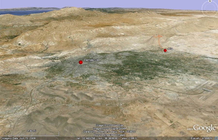
The image, above, shows Damascus and Adra with
the northeast continuation of the Mt. Hermon massif behind them. Here, I've exaggerated
the vertical scale by a factor of three so the terrain will be more readily perceived. The
view is looking north.
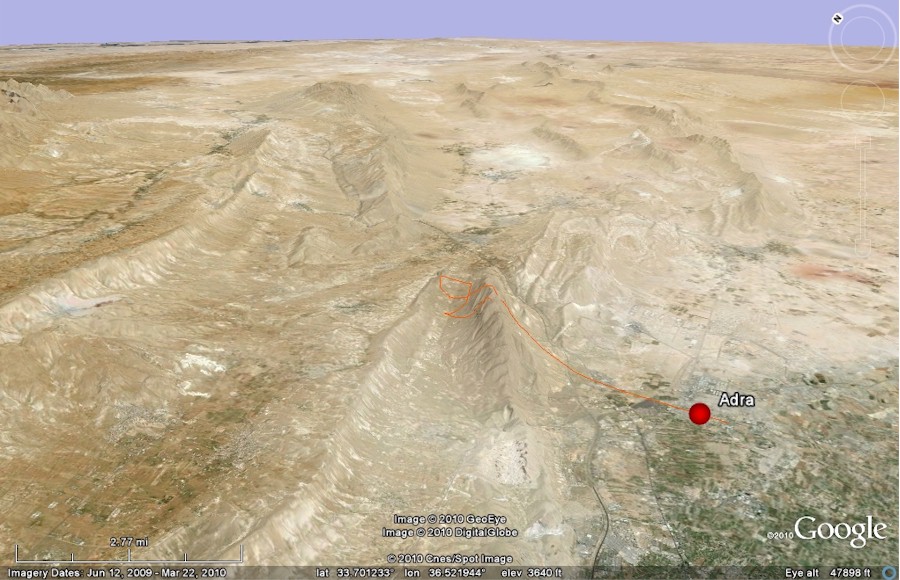
Below, the image looks northeast, following the
direction of the Hermon range. The city of Adra sits at the base of the range, which here
is characterized by a steep-faced ridge that shelters a valley behind it. This is the
"deep valley surrounded by 400-meter-high mountains" referenced in the Haaretz
article and the location of the Syrian military base where intelligence analysts believe
training in use of the missiles is being provided to Hezbollah's army for use against
Israel from their bases in Lebanon.
If you haven't done so yet, download the Google Earth plug-in.
I've created a flight that follows the red line
in the image, below. Beginning in Adra, we'll fly across the city and the agricultural
area to its north. We then climb the steep southern ridge and drop down onto the first
Scud site, where two missiles are seen in a large, unpaved staging area. Continuing, we'll
see a large mound of dirt, level and vegetated on top but white around the edges. There
are several of these on the base and are where the excavated soil from the many tunnels
dug into the surrounding mountain sides have been deposited. The newest deposits are
around the edges. Whether the mounds do double duty as covers for ammunition dumps or
bunkers for troops, I do not know.
We'll briefly fly along the valley's northern
ridge to get a sense of scale of the site and then fly to the other side - passing a
single Scud on the way - to fly along the base of the southern ridge where a network of
tunnels have been built into the mountain's base. They are concrete-reinforced and joined
by a paved, recessed road - some of which is covered to give access up and down the hill
slope across the road and to hide whatever is going on under the cover. We'll see one Scud
sticking out there.
Then, we'll fly back to the center of the valley
where three more Scuds are seen on trucks parked parallel to one another. I've marked two
additional Scud sites further down the valley, although the flight does not go there. You
can navigate on your own when the flight ends. If you're new to Google Earth, check the Flying Tips & Tricks page.
The flight ends with an ascent back up the
valley's southern ridge and a final look at the Damascus oasis in the distance.
There is no vertical exaggeration
of elevation in the flight, but the heights are still dramatic. The flight lasts just over
11 minutes if you simply click the play button on the flight controller and sit back - it
will take longer if you pause to explore and will zip past if you use the fast-forward
feature. Enjoy.
Final note -- click here for a
flight that simulates a Scud launch from Lebanon's Beka Valley targeting Ben Gurion
Airport near Tel Aviv.
Note: Sometimes
the place names do not display on the flight. The problem is intermittent and I have not
yet solved it. If you push the pause button, the place-name labels will then display.
Also, I recommend the use of Internet Explorer as your browser. Flights
are not viewable with Firefox. |