From
Dan to Beersheba ... and back again
Eight times the Old Testament
uses the phrase "from
Dan to Beersheba" - and once, "Beersheba to Dan" - to define the
territory of Israel.
Indeed, most of the Bible's
stories occur between Dan in the north and Beersheba in the south and within a dozen miles
or so of a straight line joining the two cities on a map. On this Google Earth flight, we
will fly the approximately 150 miles (as the bird flies) from Dan at the base of Mt.
Hermon, the highest peak in the region, to Beersheba, where Israel's hill country ends and
the Negev (and Sinai, beyond) begins. We won't fly a straight line - we'll be weaving back
and forth to see some important sites. We'll also fly back to Dan to view some other
important biblical regions. The other sites we miss will have to be saved for another day.
 In the north, our path
will coincide in large part with the Great Trunk Highway - the ancient pathway linking
Egypt and Mesopotamia. Abraham traveled it to come to this land, the armies of Assyria and
Babylon traveled it in their conquests, the people of Israel and Judah traveled it when
they marched into exile. The southern three-quarters of our flight will coincide with the
"water-parting route" passing through the hill country of Samaria and Judea.
This highway along the spine of the country was the most important internal route in the
land. On our return, we'll fly along the "Judean moat" where the hill country of
Judah meets the low-lying hills of the Shefelah. We'll work our way from there to the edge
of the Golan Heights and on to Dan. In the north, our path
will coincide in large part with the Great Trunk Highway - the ancient pathway linking
Egypt and Mesopotamia. Abraham traveled it to come to this land, the armies of Assyria and
Babylon traveled it in their conquests, the people of Israel and Judah traveled it when
they marched into exile. The southern three-quarters of our flight will coincide with the
"water-parting route" passing through the hill country of Samaria and Judea.
This highway along the spine of the country was the most important internal route in the
land. On our return, we'll fly along the "Judean moat" where the hill country of
Judah meets the low-lying hills of the Shefelah. We'll work our way from there to the edge
of the Golan Heights and on to Dan.
Click the play button on the
image below to begin the flight from Dan to Beersheba and back. As designed, the flight
takes slightly over two hours, although you can fast forward to complete it more quickly.
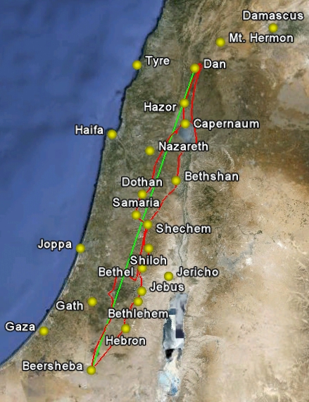
The accompanying commentary is keyed to the flight's time code. The green line you will
see is the as-the-bird-flies line between Dan and Beersheba - it's included to keep you
oriented.
In addition to biblical sites, I
have included the "Borders and Places" layer provided by Google Earth. It allows
us to see the names of modern locations (marked with a red dot in a white circle). It also
includes boundaries between nations and boundaries from the 1948 war. They are distracting
for my taste, but having them included is the only way to be able to see the modern towns
and villages. Our flight path - shown in red on the image to the right - does not display
on the flight.
Note: Sometimes
the place names do not display on the flight. The problem is intermittent and I have not
yet solved it. If you push the pause button, the place-name labels will then display.
Also, I recommend the use of Internet Explorer as your browser. Flights are not viewable
with Firefox. |